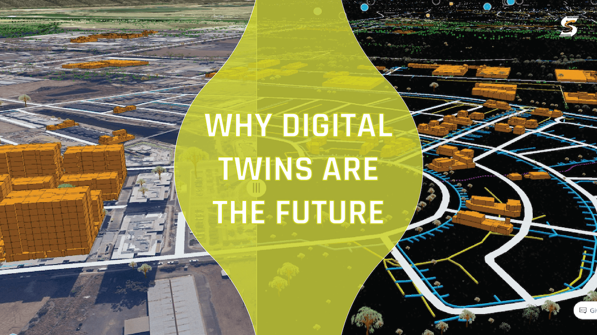
Digital Twins are a game-changer for infrastructure management and protection. In this article I'm going to outline what exactly a digital twin is, the motivation for adopting them and the momentum which is pushing us in this direction. Let's start with a definition:
"A real time, virtual representation of the real world" - Josie West 🔗
The concept of a digital twin is a virtual, visual, and geospatial representation of utility infrastructure. Digital twins are virtual replicas of physical assets or systems, created through the integration of real-time data, sensors, and advanced modeling. This technology allows utilities to have a dynamic, digital representation of their infrastructure, facilitating a deeper understanding of how assets operate in real-time.
The integration of real-time data into digital twins empowers utilities to make informed decisions, enhance operational efficiency, and ensure the reliable performance of their infrastructure. Leveraging data analytics transforms raw information into actionable insights, laying the foundation for smarter and more resilient utility operations.
Mansoor Kazerouni told Dezeen that, "The ability to create a digital representation of a building, a neighbourhood or an infrastructure network is powerful because it can inform decision-making throughout the lifecycle of that thing, starting with the design phase. Simulating data in a digital twin allows us to optimise our design." And so the case for adopting digital twins is more than just planning but also damage prevention. We know that in Chicago for example planning has been integral to their damage prevention efforts, and if the wider industry is going to reduce damages by 50% in 5 years we're going to have to follow suit.
LANDSCAPE
The basis for digital twins of cities, regions, and nations lies in digital geometric models. Developing these models, particularly for above-ground infrastructure, has been a global priority, but there is a growing recognition of the critical importance of below-ground infrastructure. Models of underground infrastructure present unique challenges, including restricted access to data, private ownership of utilities, and varied data models, symbology, and standards. Harmonizing these factors for a shared underground utility map requires collaboration among data providers. The MUDDI framework is designed to standarize how digital twins work and NUAR in the UK is the first system to use it. “It leverages cutting-edge technologies such as geographic information systems (GIS), remote sensing, data mining, and machine learning algorithms. By collecting data from various sources, including utility providers, local municipalities, construction companies, and geographic survey agencies, MUDDI creates a centralized repository of underground infrastructure information.” In my colleague Kyle Winters’ NoDamage article Clear as MUDDI, he noted six main benefits of MUDDI for damage prevention; Access to Comprehensive Data, Improved Accuracy, Visualization Tools, Conflict Identification and Resolution, Collaboration and Communication, Predictive Modeling.
RESISTANCE
The historical reliance on field inspectors is a hard habit to break due to distrust in GIS data, and this has slowed down digital twin adoption. Often stemming from inaccuracies inherited during the transition from paper maps to digital formats it’s very hard to trust a map. Companies like 4M Analytics have envisioned a world where eventually you won’t need locators in the field because mapping will be good enough. Setting aside the compliance and legal issues with that, the confidence in mapping isn’t there, for utilities to assume liabilities in my opinion I don’t think that should inhibit us from moving forward though and creating digital twins. The downsides of not doing so are significant costs and operational delays, and so we must move from a "digital mutant" to a reliable "digital twin."
The importance of data quality effects everything! We've all heard, 'garbage in, garbage out' That goes for utility maps, AI learning algorithms in Utilocate, locate reports to and especially for digital twins. So if we can improve the quality of data (accurate mapping, GPR, LiDAR etc) that will positively impact projects by lowering costs, reducing job-cycle times, enhancing safety, and preparing utilities for emerging technologies like 3D GIS and augmented reality. This is where I appeal to senior management to commit to drive this transformation and unlock the full potential of GIS as a reliable digital twin.
EXAMPLES OF DIGITAL TWINS
-
Brisbane - 🔗
In Brisbane, Australia a digital twin and virtual reality program has been employed to guide the design and construction of an underground railway in Brisbane, Australia. The Cross River Rail project aims to address population growth by adding a 10.2-kilometer line with twin tunnels, four new underground stations, and upgrades to existing stations. Learning from the Crossrail project in London, the Cross River team implemented three key recommendations: creating a common data environment, using a federated BIM model, and making the model immersive through virtual reality. The digital twin, encompassing GIS and BIM, provides an immersive experience for stakeholders and aids in project visualization, design, and construction. The continuous expansion of the digital twin is important and will help the city expand their damage prevention and planning operations as they expand.
-
NUAR - 🔗
I've already mentioned it earlier in this article and multiple times in others but for damage prevention and digital twins, NUAR in the UK is the best example and is really the first of its type to use MUDDI! The UK's Geospatial Commission launched the first phase of the National Underground Asset Register (NUAR), a digital map aimed at transforming the management of pipes and cables buried underground. The NUAR is already helping to streamline projects such as new roads, housing, broadband, and infrastructure for electric vehicle charging and flood management. With data from public and private sector organizations in North East England, Wales, and London, the map aims to reduce the economic cost of accidental utility damage (estimated at £2.4 billion annually) and enhance construction efficiency. It's expected to deliver at least £350 million in economic benefits per year when fully operational across England, Wales, and Northern Ireland. The Greater London Authority's Infrastructure Team sees NUAR as a supporting tool for infrastructure coordination, reducing road network disruption and contributing to London's Economic Recovery Framework. The digital twin is managed by engineering firm Atkins and is envisioned to continuously expand, offering economic benefits and aiding in infrastructure planning and management.
CONCLUSION
In summary, digital twins are revolutionizing infrastructure management by providing real-time virtual representations of physical assets. Motivated by the ability to enhance decision-making, operational efficiency, and infrastructure reliability, the adoption of digital twins is gaining momentum. The MUDDI framework, exemplified by the National Underground Asset Register (NUAR) in the UK, standardizes underground utility mapping, leveraging advanced technologies for comprehensive data access and improved accuracy.
Despite historical resistance, transitioning from a "digital mutant" to a reliable "digital twin" is crucial for avoiding costs and delays. Improving data quality through accurate mapping is essential. Examples like Brisbane's underground railway and NUAR showcase successful digital twin implementations, demonstrating their practical benefits and potential for continuous expansion in infrastructure planning and damage prevention. A commitment from senior management is essential to unlock the full potential of GIS as a reliable digital twin on a global scale.
RECENT POSTS

LATEST FROM NO DAMAGE
Share this Post